Tag: geolocation 124 documents
Search documents matching “geolocation” →Free-text subjects the curators added. Unlike the other axes these are not necessarily from the documents' own vocabulary, so they are the loosest thing to browse by (and the most forgiving).
Graphs
By document date (11 years)
By Banner
By Classification
Refine (combine with another filter, via search)
Sort: Title
Documents
-
CRISSCROSS/PROTON Point Paper [pdf]
Originating as a CIA/DEA joint venture in the 1990s, CRISSCROSS/PROTON is a centralized repository used by five U.S. agencies (CIA, DEA, NSA, DIA, FBI) for massive link analysis and contact chaining. The document details how the NSA provides billions of telephony records to the system to assist in capturing High Value Individuals (HVIs) but recommends transitioning to an NSA-led architecture using the GLOBALREACH federated query service.
-
EAGLEVIEW -- A Data Processing Tool for GSM Cellular Networks SIDtoday [pdf]
A system called "EAGLEVIEW" helps analysts map out GSM cellular phone networks. The system takes information collected in the field and plots out network coverage.
The Intercept ↗ (2017-09-13) -
Elegant Chaos: collect it all, exploit it all [pdf]
This document outlines a classified project, "Elegant CHAOS," focused on advanced signals intelligence (SIGINT) collection, processing, and analysis using cutting-edge technologies like automated surveys and modems. It highlights goals such as real-time data analysis, collaboration with international partners, and integration with cloud-based platforms to manage massive data. See also the document with notes (by GCHQ): "Elegant-Chaos-collect-it-all-exploit-it-all-plus"
Programs: ELEGANTCHAOS · ASPHALT · ASPHALT-A · ASPHALT-A-PLUS · STORMFORCE · DARKQUEST · TORUS · XKEYSCORE · MHS CLOUD · TURMOIL · TARMAC · ASDF · SLR · POPQUIZ · WEALTHYCLUSTER2 · TRAVELLINGWAVE · BILBOBADGER · DRINKYBIRD · GLOBETROTTER · MASTERSHAKE · REST · TRAFFICTHIEF · VENUSAFFECT · FOGHORN · MATCHMAKER · ROADBED · MOONPENNY · AMULETSTELLAR · CLOUD · WEALTHYCLUSTER · MVR · TINT · IPGEOTRAP · MARINA · PLUS -
Elegant Chaos: collect it all, exploit it all (plus notes) [pdf]
GCHQ/NSA presentation describing ELEGANT CHAOS — an automated system at the Menwith Hill Station satellite interception facility that scores and ranks thousands of intercepted satellite signals by intelligence value, automatically deciding which ones deserve collection resources based on criteria like geographic location, target network hits, technology type and Computer Network Operations interest — built to implement the station's directive to "Sniff it All, Know it All, Collect it All, Process it All, Exploit it All, Partner it All" as collection capacity scaled from 100 signals to a planned 3,000 simultaneous intercepts.
Programs: ELEGANTCHAOS · ASPHALT · ASPHALT-A · ASPHALT-A-PLUS · STORMFORCE · DARKQUEST · TORUS · XKEYSCORE · MHS CLOUD · TURMOIL · TARMAC · ASDF · SLR · POPQUIZ · WEALTHYCLUSTER2 · TRAVELLINGWAVE · BILBOBADGER · DRINKYBIRD · GLOBETROTTER · MASTERSHAKE · REST · TRAFFICTHIEF · VENUSAFFECT · FOGHORN · MATCHMAKER · ROADBED · MOONPENNY · WHIZBANG · CLOUDBASE · APLUS · MAILORDER · CROSSBONES · AMULET STELLAR · MVR · TINT · WEALTHYCLUSTER · IPGEOTRAP · MARINA · CLOUD · PLUS -
Embedded with USSOCOM: NSA Reps Provide Direct Analytic Support SIDtoday [pdf]
The NSA helped U.S. special forces “discover a vast and disparate network of Iranian agents in Iraq serving the Iranian Ministry of Intelligence ... or the Islamic Revolutionary Guards Corps.” Analysts embedded with special forces also help to find enemy safe houses, “ratlines,” and VIP facilities.
People: Brown, Bryan D.The Intercept ↗ (2018-08-15) -
FASCIA: The NSA's huge trove of location records [pdf]
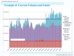
FASCIA is the National Security Agency's enormous database containing trillions of metadata records, many with device locations, that are collected from a variety of sources. This document shows the volume and types of device-location data collected by the agency.
“NSA tracking cellphone locations worldwide, Snowden documents show” - The Washington Post ↗ (2013-12-04) · “No Place to Hide” - Metropolitan Books ↗ (2014-05-13) · Gellman, Barton · Soltani, Ashkan · Greenwald, Glenn -
First Overhead Partnership Conference (OPC) Held SIDtoday [pdf]
Representatives from a wide range of U.S. government and foreign partner agencies met for five days in May 2005 to discuss overhead (satellite and spaceborne) collection of signals intelligence, with information-sharing as the major theme.
Programs: RAINFALLPeople: Schiavone, DeniseThe Intercept ↗ (2018-03-01) -
Follow the 'Honey' SIDtoday [pdf]
An Iraqi target ”known to take his cell phone completely apart when he went home to prevent our tracking” is located and caught by tracking his wife's cell phone.
“Mission Creep: How the NSA’s Game-Changing Targeting System Built for Iraq and Afghanistan Ended Up on the Mexico Border” - The Intercept ↗ (2019-05-29) · “Norges hemmelige krig i Afghanistan” - NRK ↗ (2019-05-29) · The Intercept ↗ (2019-05-29) · Moltke, Henrik · Skille, Øyvind Bye · Døvik, Olav · Hansen, Ståle Ellingsgard · Fjørtoft, Martin -
FORNSAT technologies [pdf]
This document outlines a Foreign Satellite Communication Exploitation Model targeting satellite systems such as Intelsat, Iridium, Hughes, ND SatCom, and Inmarsat, using both fixed and mobile satellite services. It describes specific collection and geolocation systems—SEADIVER, ZODIACARRAY, and CANYONDUST—that capture and process voice, fax, data, and terminal location information across global coverage areas.
Programs: SHAREDVISION · DARKQUEST · EKB · GLOBALVIEW · TRYST · ZODIACARRAY · CANYONDUST · IRIDIUM · SEADIVER -
From the Sandbox to Mexico: Applying Wartime Tactical Techniques to Strategic Missions SIDtoday [pdf]
Systems developed for the "sandbox” (Iraq) such as pattern-of-life-analysis and phone geolocation are now used against drug criminals on the US-Mexico border.
People: Carrillo Fuentes, Vicente“Mission Creep: How the NSA’s Game-Changing Targeting System Built for Iraq and Afghanistan Ended Up on the Mexico Border” - The Intercept ↗ (2019-05-29) · “Norges hemmelige krig i Afghanistan” - NRK ↗ (2019-05-29) · The Intercept ↗ (2019-05-29) · Moltke, Henrik · Skille, Øyvind Bye · Døvik, Olav · Hansen, Ståle Ellingsgard · Fjørtoft, Martin -
FY2013 Congressional Budget Justification Bin Laden Excerpts [pdf]
This document includes excerpts from the 2013 National Intelligence Program budget justification describing the integrated intelligence community efforts that led to locating and raiding Osama bin Laden's compound, detailing contributions from NSA's signal intelligence, CIA's geolocation analysis, NGA's imagery modeling, and post-raid forensic DNA confirmation.
People: bin Laden, Osama -
GCHQ Analytic Cloud Challenges [pdf]
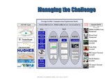
The 2012 GCHQ Analytic Cloud document outlines a sophisticated data processing infrastructure handling approximately 50 billion daily events across multiple sites, utilizing QFD databases and HADOOP clusters for various analytic capabilities targeting intelligence gathering and analysis. It describes architectural components, challenges in scaling and enabling analysts to cope with data complexity, and proposes future technology options including consolidation approaches and new cloud architectures to enhance capabilities.
Programs: EVOLVEDMUTANTBROTH · MUTANTBROTH · HARDASSOC · HRMAP · KARMAPOLICE · SOCIALANTHROPOID · AUTOASSOC · GEOFUSION · MVR · TERRAIN · SALAMANCA · BLACKHOLE · SAMUELPEPYS · BROKER · VAIL · GUIDINGLIGHT · FIRSTCONTACT · CLOUDYCOBRA · RUMOURMILL · EVERYASSOC · EVERYPOLICE · EVERYCREATURE · EVERYEAD · EVERYCIPHER · GREYFOX · SILVERFOX · GOLDENAXE · TRIBALCARNEM · PUBLICANEMONE · EPICFAIL · STERLINGMOTH · FOGHORN · LOOKINGGLASS · FIREENGINE · NGGEO · ALPHACENTAURI · CLOUDBASE · ACCUMULO · ASEM · SEM · HAKIM · STREAMING · HBASE · LAUREL · SKINNYCLOUD · HARDY · GCHQCORE -
GCHQ Perspective on Annual Bilat SIDtoday [pdf]
Topics at an annual meeting between the Signals Intelligence Directorate and its GCHQ counterpart included the relative paucity of GCHQ efforts in China, the need to devote sufficient resources to Russia and weapons of mass destruction in the face of counterterrorism mandates, and the need to better geolocate targets, writes GCHQ's director for signals intelligence operations.
The Intercept ↗ (2017-09-13) -
GEOCELL Supports IRAQI FREEDOM SIDtoday [pdf]
The Geospatial Exploitation Office, on 24/7 watch for the Iraq War, assisted in the mapping of geolocation communications data in near real time for high-value targets and threat activity.
Programs: GEOCELLThe Intercept ↗ (2016-05-16) -
Getting Leads: GEO Mining SIDtoday [pdf]
Description of an approach to sifting through large amounts of phone call metadata to find leads for new surveillance target called "GEO Mining." The author gives an example of searching for heroin-production labs in Afghanistan using GEO Mining, by filtering all phone calls in Afghanistan down to calls made near known heroin-processing labs. In this case, "The top 20 handsets were then tasked for collection, and at least one has produced reportable intelligence."
People: Brown, PaulThe Intercept ↗ (2017-04-24) -
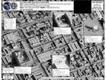
GHOSTHUNTER aerial image (2009) [pdf]
This imagery showcases a real-world application of the GHOSTHUNTER program operated out of Menwith Hill Station in the UK. The document features an aerial satellite photograph used to pinpoint the precise physical location of VSAT (Very Small Aperture Terminal) satellite dishes. By linking a target's digital footprint—specifically their MAC address and IP address—to a specific set of geographic coordinates, the NSA and GCHQ can identify the exact building or compound where a person is using the internet. This capability is a cornerstone of the "find, fix, finish" cycle used to support "covert operations" and targeted killing missions in conflict zones like Yemen, Somalia, and Afghanistan.
Programs: GHOSTHUNTER -
Gold Nugget Award Bestowed SIDtoday [pdf]
A staffer was given an award for outstanding achievement in Traffic Analysis, including identifying and geolocating insurgents and terrorists.
Programs: VOICESAILPeople: Johnson, CarlThe Intercept ↗ (2017-09-13) -
GSM Temporary Selectors - Breakthroughs in Automated Identification SIDtoday [pdf]
It has always frustrated analysts when GSM cellular networks implement Temporary Mobile Subscriber Identities, which obscure a code, known as IMSI, that uniquely and persistently identifies the cellphone. The "ASSOCIATION" program has solved this problem by mapping TMSI to IMSI.
The Intercept ↗ (2018-03-01) -
Guide to Using Contexts in XKS Fingerprints [pdf]
This technical guide explains how NSA analysts use "contexts" within XKEYSCORE fingerprints to create highly targeted surveillance queries by restricting searches to specific scopes (e.g., web searches, document bodies, geographic locations), enabling precision targeting such as finding "all people in Kabul performing web searches on Jihad" while avoiding the overwhelming noise of broader keyword searches.
-
How the NSA Accesses Smartphone Data [pdf]
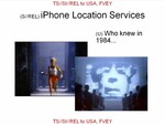
This document reveals how the NSA and its Five Eyes partners developed sophisticated methods to exploit iPhone location services and BlackBerry communications, framing smartphone users as “zombies” willingly sharing data. It includes examples of intercepted geolocation data and decrypted BlackBerry emails, illustrating targeted surveillance capabilities against both consumer and government communications.