Publication year: 2016 73 documents
Search documents matching “2016” →When a publisher first published each document. If a document is published multiple times, only the oldest one is used here.
Graphs
By document date (8 years)
Sort: Title
Documents
-
-
GHOSTHUNTER aerial image (2009) [pdf]
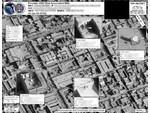
This imagery showcases a real-world application of the GHOSTHUNTER program operated out of Menwith Hill Station in the UK. The document features an aerial satellite photograph used to pinpoint the precise physical location of VSAT (Very Small Aperture Terminal) satellite dishes. By linking a target's digital footprint—specifically their MAC address and IP address—to a specific set of geographic coordinates, the NSA and GCHQ can identify the exact building or compound where a person is using the internet. This capability is a cornerstone of the "find, fix, finish" cycle used to support "covert operations" and targeted killing missions in conflict zones like Yemen, Somalia, and Afghanistan.
Programs: GHOSTHUNTER -
Ghosthunter and the geolocating of internet cafes [pdf]
This document announces an NSA “R Spotlight” webcast introducing GHOSTHUNTER, a multi-agency geolocation program designed to locate Time Division Multiple Access (TDMA) VSAT Internet access points, particularly internet cafés across the Middle East and North Africa in support of U.S. military operations. By mid-2009, GHOSTHUNTER had successfully geolocated over 5,000 VSAT terminals across Middle East demonstrating its operational effectiveness and integration with broader intelligence efforts.
Programs: GHOSTHUNTER -
Ghosthunter future capabilities (2008) [pdf]
This document indicates that Menwith Hill Station (MHS) provides approximately 99% of the FORNSAT data used by GHOSTHUNTER for geolocating targets, while additional FORNSAT sites can be tapped as needed to cover other regions. Although GHOSTHUNTER offers near-global geolocation capabilities, certain areas remain blind spots where coverage is limited.
Programs: GHOSTHUNTER -
GHOSTHUNTER Goes Global [pdf]
This document announces that GHOSTHUNTER, operated from Menwith Hill Station (MHS), is being used to geolocate terminals associated with high-value targets in Iraq and surrounding Middle Eastern countries. It references a hyperlinked article in the station’s Horizon newsletter for further details, which requires a secure NTS-PKI certificate to access due to its classification. The title suggests that GHOSTHUNTER has achieved global reach.
Programs: GHOSTHUNTER -
GHOSTHUNTER Tasking Process [pdf]
The document outlines the GHOSTHUNTER (GH) tasking process at Menwith Hill Station, describing how geolocation requests for VSAT terminals and internet-connected targets are managed through coordination with the NSA’s Network Analysis Centre (NAC) and other sites. It details priority levels, task submission procedures, use of locational data from MASTERSHAKE, integration with imagery, and how results are shared with GCHQ and other authorized parties.
-
GSM tower geolocation [pdf]
This TOP SECRET STRAP 1 note describes DYMO, a prototype GSM-tower geolocation system that combines RUFIS-bis (which demodulates co-channel GSM ARFCN streams per cell-ID) with WHAMI Fast Image (WFI) to remodulate and correlate signals to produce high-quality tower geolocation and matching metadata. The remodulated “synthetic geolocation” improves accuracy and is under development in the NMDC/Midas studies.
-
GSM tower mapping made easier and more accurate with new tool SIDtoday [pdf]
This document details DYMO, a prototype developed at the NSA’s Menwith Hill Station—the agency’s large British base operated in close cooperation with GCHQ—for highly accurate GSM tower geolocation. It highlights DYMO’s superior performance in mapping accuracy and metadata integrity, its extensive operational use across regions such as Iraq, Iran, and Somalia, and its integration with tools like GOLDENEYE and the Integrated COMINT System (ICS) to streamline analysis and intelligence fusion.
-
HIMR Data Mining Research Problem Book [pdf]
This document is a research roadmap created by GCHQ for the Heilbronn Institute for Mathematical Research (HIMR). Its purpose is to guide long-term mathematical and data-mining research that could improve signals intelligence (SIGINT) capabilities. It outlines key research problems, datasets, and collaboration plans between intelligence agencies and academic researchers. The main goal is to develop new algorithms and mathematical tools to analyze extremely large communications datasets produced by modern surveillance systems.
Programs: CLOUD · DISTILLERY · DISCOVER · PRESTON · LECKWITH · TERRAIN · BROADOAK · NGE · FIVEALIVE · CHARTBREAKER · FIRSTCONTACT · GEOFUSION · RADONSHARPEN-B · PRIMETIME · HIDDENOTTER · BAKERSDOZEN · CLASP · SALTYOTTER · BIRCH · SOLIDINK · FLUIDINK · MAMBA · GRINNINGROACH · PIRATECAREBEAR · AUTOASSOC · CROUCHINGSQUIRREL · HRMAP · KACHINA · SQUEAL · QUESTA · METEORSHOWER · SUNSTORM · GOLDMINE · HAGERAWEL · WOODY · BUZZ · SILVERLIBRARY · SILVERLINING · VALHALLA · MOUNTMCKINLEY · SEPANG · BLACKHOLE · SALAMANCA · HAGELAWEL · LUCKYSTRIKE · SPIKYROCK · MYOFIBRIL · INJUNCTION · PSYCHICSALMON · RAGINGBULLFROG · ROBOTICFISH · TIMIDTOAD · AURA · CARBONCOPY · CASK · CHORDAL · CRAN · INSTINCT · MADFORGE · SWAMP · VOLSUNGA · WHITERAVEN · MVR · PPF · JTRIG · MAPREDUCE · MAILORDERPeople: Tukey, John -
In-Flight GSM [pdf]
This NSA presentation outlines how the agency is reacting to the growth of mobile phone services on board commercial aircraft.
-
Introduction to BADDECISION [pdf]
This presentation details the use of the NSA program BADDECISION, which is a computer network exploitation tool (CNE) that uses a frame injection technique to redirect the target client to a FOXACID server.
-
Introduction to WLAN / 802.11 Active CNE Operations [pdf]
This NSA powerpoint introduces computer network exploitation (CNE) criteria and assesment as well as active CNE operations. It also introduces the FOXACID program, which is a program to deliver content based exploits to web browsers.
-
ISUAV Video Descrambling [pdf]
The document details how GCHQ analysts intercepted and descrambled scrambled analogue video from Israeli UAVs using a "cut & slide" technique similar to Sky TV’s old VideoCrypt system. By applying open-source tools like Antisky, they could reconstruct individual video frames, enabling near-perfect image recovery despite heavy processing demands.
Marking: SECRET -
James Clapper's Classified Blog [pdf]
This document reveals that James Clapper, as Director of National Intelligence, maintained a classified blog called “Intercept” where he publicly responded to a citizen letter supporting expanded domestic surveillance after the Boston Marathon bombings. While Clapper endorsed the premise of sacrificing some civil liberties for security, internal commenters cautioned against eroding constitutional rights, emphasizing that increased surveillance does not guarantee safety.
-
-
Learning to Love English SIDtoday [pdf]
In this SIDtoday article Chief Warrant Officer John Berry reflects on his journey to appreciating the nuances of the English language, from early advice by a mentor in journalism to his experiences as a technical writer.
People: Berry, John F. -
Longest Shifts: Working Overtime in Pursuit of SIGINT (part 2: conclusion) SIDtoday [pdf]
To mark Labor Day, SIDtoday shared stories from NSA personnel about their longest shifts. The accounts highlighted the dedication, stress, and sacrifice involved in supporting critical SIGINT operations, from intense 48-hour shifts during military operations to working long hours in extreme conditions like snowstorms or following major events like 9/11.
People: Blum, H. Steven -
Menwith collection assets SIDtoday [pdf]
In 2009, Menwith Hill Station (MHS) planned to receive two new satellites to expand its signals intelligence collection capabilities, enabling broader coverage of China, Afghanistan, Pakistan, Latin America, the Middle East, and North Africa. The new assets were intended to enhance mission flexibility, support FORNSAT collection, and provide the intelligence community with opportunities for discovery, analysis, and sustained monitoring from space.
-
Menwith continues successful counterterrorism survey along Af-Pak border [pdf]
Menwith Hill Station (MHS) conducted a counterterrorism surveillance operation along the Afghanistan-Pakistan border using the DARKSIDE collection system, successfully intercepting and processing microwave communications to gather actionable intelligence on terrorist activities. The operation, enhanced by Phase II hardware and coordinated with regional target offices, allowed dynamic capture and analysis of multiple signals to support ongoing counterterrorism efforts.
-
Menwith databases as of Aug 2008 [pdf]
This document outlines database access and SIGINT missions at Menwith Hill Station (MHS) as of August 2008, detailing the specific programs, language branches, and target development teams supported, including repositories like DISHFIRE, MAINWAY, and PINWALE. It also notes that U.S. personnel use the SIGINT Contact Center (SCC) process for access, with certain NOFORN restrictions, and lists additional analytic tools available to MHS analysts.
Marking: CONFIDENTIALPrograms: ASSOCIATION · DISHFIRE · HOMEBASE GEO · MAINWAY · NUCLEON · PINWALE · SPOTBEAM · XKEYSCORE · BANYAN · BROOMSTICK · CULTWEAVE II · MARINA · TRAFFICTHIEF · FASCIA · OCTSKYWARD · ROADBED · TUNNINGFORK · AGILITY · CADENCE · CONTRAOCTAVE · GAMUT · UTT · NKB · OCTAVE · PUZZLECUBE · TKB