UK special forces Reaper drone (Jan-Feb-2012)
Open PDFDocument date: 2012-03
Pages: 1
Genre: other
Classification: -
Dissemination: -
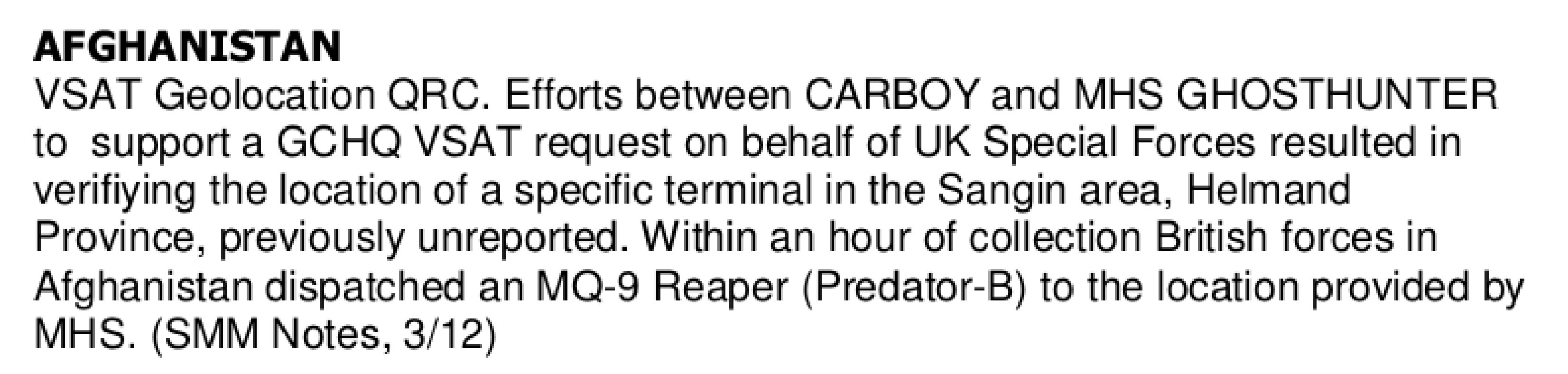
This NSA document from March 2012 describes how NSA and GCHQ geolocation efforts in Afghanistan pinpointed a previously unknown VSAT terminal in Helmand Province for UK Special Forces, who dispatched an MQ-9 Reaper drone to the location within an hour of receiving the intelligence.
My notes
AFGHANISTAN
VSAT Geolocation QRC. Efforts between CARBOY and MHS GHOSTHUNTER to support a GCHQ VSAT request on behalf of UK Special Forces resulted in verifying the location of a specific terminal in the Sangin area, Helmand Province, previously unreported. Within an hour of collection British forces in Afghanistan dispatched an MQ-9 Reaper (Predator-B) to the location provided by MHS. (SMM Notes, 3/12)
Published in the Same Report
(10 of 26 documents)
-
APPARITION Becomes a Reality: New Corporate VSAT-Geolocation Capability Sees Its First Deployment SIDtoday [pdf]
This document provides an update to the APPARITION system, which is designed to provide precision geolocation information for VSAT terminals. APPARITION, as contrasted with GHOSTHUNTER, is designed to proactively target and geolocate VSATs and for that information to be populated in MASTERSHAKE. The result is that any location will be able to combine VSAT information with FORNSAT information to geolocate targets.
-
Afghanistan 30 enemy killed (Jan-Feb 2012) [pdf]
Taliban high-value targets in Afghanistan shifted to VSAT-based communications, which NSA and GCHQ analysts in Menwith Hill linked to known phone numbers. This intelligence enabled military operations that killed about 30 enemy fighters.
Marking: TOP SECRET -
APPARITION/GHOSTHUNTER TASKING INFO [pdf]
The document details how the NSA’s and GCHQ’s GHOSTHUNTER and APPARITION systems, based primarily at Menwith Hill Station, are used to geolocate VSAT satellite modems for both real-time operational support and strategic intelligence. It explains tasking priorities, coordination processes, and how geolocation results are shared through systems like Mastershake to support surveillance and capture/kill missions.
Programs: APPARITION · GHOSTHUNTER · SOUNDER · CARD · LADYLOVE · JACKNIFE · MOONPENNY · CARBOY · MASTERSHAKE · TRYST -
Elegant Chaos: collect it all, exploit it all [pdf]
This document outlines a classified project, "Elegant CHAOS," focused on advanced signals intelligence (SIGINT) collection, processing, and analysis using cutting-edge technologies like automated surveys and modems. It highlights goals such as real-time data analysis, collaboration with international partners, and integration with cloud-based platforms to manage massive data. See also the document with notes (by GCHQ): "Elegant-Chaos-collect-it-all-exploit-it-all-plus"
Programs: ELEGANTCHAOS · ASPHALT · ASPHALT-A · ASPHALT-A-PLUS · STORMFORCE · DARKQUEST · TORUS · XKEYSCORE · MHS CLOUD · TURMOIL · TARMAC · ASDF · SLR · POPQUIZ · WEALTHYCLUSTER2 · TRAVELLINGWAVE · BILBOBADGER · DRINKYBIRD · GLOBETROTTER · MASTERSHAKE · REST · TRAFFICTHIEF · VENUSAFFECT · FOGHORN · MATCHMAKER · ROADBED · MOONPENNY · AMULETSTELLAR · CLOUD · WEALTHYCLUSTER · MVR · TINT · IPGEOTRAP · MARINA · PLUS -
Elegant Chaos: collect it all, exploit it all (plus notes) [pdf]
GCHQ/NSA presentation describing ELEGANT CHAOS — an automated system at the Menwith Hill Station satellite interception facility that scores and ranks thousands of intercepted satellite signals by intelligence value, automatically deciding which ones deserve collection resources based on criteria like geographic location, target network hits, technology type and Computer Network Operations interest — built to implement the station's directive to "Sniff it All, Know it All, Collect it All, Process it All, Exploit it All, Partner it All" as collection capacity scaled from 100 signals to a planned 3,000 simultaneous intercepts.
Programs: ELEGANTCHAOS · ASPHALT · ASPHALT-A · ASPHALT-A-PLUS · STORMFORCE · DARKQUEST · TORUS · XKEYSCORE · MHS CLOUD · TURMOIL · TARMAC · ASDF · SLR · POPQUIZ · WEALTHYCLUSTER2 · TRAVELLINGWAVE · BILBOBADGER · DRINKYBIRD · GLOBETROTTER · MASTERSHAKE · REST · TRAFFICTHIEF · VENUSAFFECT · FOGHORN · MATCHMAKER · ROADBED · MOONPENNY · WHIZBANG · CLOUDBASE · APLUS · MAILORDER · CROSSBONES · AMULET STELLAR · MVR · TINT · WEALTHYCLUSTER · IPGEOTRAP · MARINA · CLOUD · PLUS -
GSM tower geolocation [pdf]
This TOP SECRET STRAP 1 note describes DYMO, a prototype GSM-tower geolocation system that combines RUFIS-bis (which demodulates co-channel GSM ARFCN streams per cell-ID) with WHAMI Fast Image (WFI) to remodulate and correlate signals to produce high-quality tower geolocation and matching metadata. The remodulated “synthetic geolocation” improves accuracy and is under development in the NMDC/Midas studies.
-
GSM tower mapping made easier and more accurate with new tool SIDtoday [pdf]
This document details DYMO, a prototype developed at the NSA’s Menwith Hill Station—the agency’s large British base operated in close cooperation with GCHQ—for highly accurate GSM tower geolocation. It highlights DYMO’s superior performance in mapping accuracy and metadata integrity, its extensive operational use across regions such as Iraq, Iran, and Somalia, and its integration with tools like GOLDENEYE and the Integrated COMINT System (ICS) to streamline analysis and intelligence fusion.
-
Ghosthunter and the geolocating of internet cafes [pdf]
This document announces an NSA “R Spotlight” webcast introducing GHOSTHUNTER, a multi-agency geolocation program designed to locate Time Division Multiple Access (TDMA) VSAT Internet access points, particularly internet cafés across the Middle East and North Africa in support of U.S. military operations. By mid-2009, GHOSTHUNTER had successfully geolocated over 5,000 VSAT terminals across Middle East demonstrating its operational effectiveness and integration with broader intelligence efforts.
Programs: GHOSTHUNTER -
Ghosthunter future capabilities (2008) [pdf]
This document indicates that Menwith Hill Station (MHS) provides approximately 99% of the FORNSAT data used by GHOSTHUNTER for geolocating targets, while additional FORNSAT sites can be tapped as needed to cover other regions. Although GHOSTHUNTER offers near-global geolocation capabilities, certain areas remain blind spots where coverage is limited.
Programs: GHOSTHUNTER -
GHOSTHUNTER Goes Global [pdf]
This document announces that GHOSTHUNTER, operated from Menwith Hill Station (MHS), is being used to geolocate terminals associated with high-value targets in Iraq and surrounding Middle Eastern countries. It references a hyperlinked article in the station’s Horizon newsletter for further details, which requires a secure NTS-PKI certificate to access due to its classification. The title suggests that GHOSTHUNTER has achieved global reach.
Programs: GHOSTHUNTER

Related Documents
-
APPARITION/GHOSTHUNTER TASKING INFO [pdf]
The document details how the NSA’s and GCHQ’s GHOSTHUNTER and APPARITION systems, based primarily at Menwith Hill Station, are used to geolocate VSAT satellite modems for both real-time operational support and strategic intelligence. It explains tasking priorities, coordination processes, and how geolocation results are shared through systems like Mastershake to support surveillance and capture/kill missions.
Programs: APPARITION · GHOSTHUNTER · SOUNDER · CARD · LADYLOVE · JACKNIFE · MOONPENNY · CARBOY · MASTERSHAKE · TRYST -
UK AIRHANDLER trainees [pdf]
This GCHQ document from 2008 describes British AIRHANDLER trainees at NSA Georgia receiving recognition for their operational performance supporting drone surveillance missions, with personnel from UK's Joint Service Signal Unit Digby being trained to operate SIGINT collection packages on Predator unmanned aerial vehicles. The document reveals that Digby was being established as only the second site worldwide (after NSA Georgia) capable of handling the "back end" processing of Predator drone intelligence collection after the UK purchased three Predator drones.
Marking: SECRETPrograms: AIRHANDLER -
Metadata-Driven Drone Strikes SIDtoday [pdf]
These documents describe the NSA and CIA’s use of geolocation technology, particularly via UAV-mounted systems like GILGAMESH and VICTORYDANCE, to track mobile devices for targeted drone strikes, including operations that killed U.S. citizen Anwar Nasser Aulaqi. These programs rely heavily on signals intelligence rather than human confirmation, raising concerns about reliability, civilian casualties, and the accuracy of targeting. See also: SIDtoday/documents/2005/2005-01-18_SIDToday_-_New_Tactical_Collection_System_Joins_the_War_on_Terroris
-
GHOSTHUNTER aerial image (2009) [pdf]
This imagery showcases a real-world application of the GHOSTHUNTER program operated out of Menwith Hill Station in the UK. The document features an aerial satellite photograph used to pinpoint the precise physical location of VSAT (Very Small Aperture Terminal) satellite dishes. By linking a target's digital footprint—specifically their MAC address and IP address—to a specific set of geographic coordinates, the NSA and GCHQ can identify the exact building or compound where a person is using the internet. This capability is a cornerstone of the "find, fix, finish" cycle used to support "covert operations" and targeted killing missions in conflict zones like Yemen, Somalia, and Afghanistan.
Programs: GHOSTHUNTER -
Afghanistan 30 enemy killed (Jan-Feb 2012) [pdf]
Taliban high-value targets in Afghanistan shifted to VSAT-based communications, which NSA and GCHQ analysts in Menwith Hill linked to known phone numbers. This intelligence enabled military operations that killed about 30 enemy fighters.
Marking: TOP SECRET