Publication year: 2016 760 documents
Search documents matching “2016” →When a publisher first published each document. If a document is published multiple times, only the oldest one is used here.
Graphs
By document date (11 years)
By published date (4 years)
Sort: Title
Documents
-
Generally Speaking: Learning Lessons from CSTs in Iraq SIDtoday [pdf]
The Signals Intelligence director spoke with five analysts who served in the field in Iraq to gather feedback about their experience and how to improve the entire SIGINT system to make it more effective.
People: Quirk, RichardThe Intercept ↗ (2016-08-10) -
Generally Speaking: Supporting the Tactical Units SIDtoday [pdf]
The Signals Intelligence director says SID has done a good job delivering SIGINT to high-ranking commanders, but it hasn’t been as successful delivering to tactical units on the ground. He describes the work done so far to change that.
People: Quirk, RichardThe Intercept ↗ (2016-08-10) -
GEOCELL Supports IRAQI FREEDOM SIDtoday [pdf]
The Geospatial Exploitation Office, on 24/7 watch for the Iraq War, assisted in the mapping of geolocation communications data in near real time for high-value targets and threat activity.
Programs: GEOCELLThe Intercept ↗ (2016-05-16) -
Geospatial Information Systems (GIS) Certificate Program SIDtoday [pdf]
NSA partnered with George Mason University to provide a certificate program in Geospatial Information Systems. The course uses ESRI spatial analysis tools.
Programs: GISThe Intercept ↗ (2016-08-10) -
Get Ready for Foreign Language Week, September 15-19 SIDtoday [pdf]
Announcing Foreign Language Week at NSA.
The Intercept ↗ (2016-08-10) -
Getting an Expert Opinion SIDtoday [pdf]
Describes the new E-document Sharing Program, designed to let analysts share SIGINT ”stripped of references to its source” with technical experts who can help understand it, using computers to avoid travel.
Programs: IWSThe Intercept ↗ (2016-08-10) -
GHOSTHUNTER aerial image (2009) [pdf]
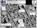
This imagery showcases a real-world application of the GHOSTHUNTER program operated out of Menwith Hill Station in the UK. The document features an aerial satellite photograph used to pinpoint the precise physical location of VSAT (Very Small Aperture Terminal) satellite dishes. By linking a target's digital footprint—specifically their MAC address and IP address—to a specific set of geographic coordinates, the NSA and GCHQ can identify the exact building or compound where a person is using the internet. This capability is a cornerstone of the "find, fix, finish" cycle used to support "covert operations" and targeted killing missions in conflict zones like Yemen, Somalia, and Afghanistan.
Programs: GHOSTHUNTER -
Ghosthunter and the geolocating of internet cafes [pdf]
This document announces an NSA “R Spotlight” webcast introducing GHOSTHUNTER, a multi-agency geolocation program designed to locate Time Division Multiple Access (TDMA) VSAT Internet access points, particularly internet cafés across the Middle East and North Africa in support of U.S. military operations. By mid-2009, GHOSTHUNTER had successfully geolocated over 5,000 VSAT terminals across Middle East demonstrating its operational effectiveness and integration with broader intelligence efforts.
Programs: GHOSTHUNTER -
Ghosthunter future capabilities (2008) [pdf]
This document indicates that Menwith Hill Station (MHS) provides approximately 99% of the FORNSAT data used by GHOSTHUNTER for geolocating targets, while additional FORNSAT sites can be tapped as needed to cover other regions. Although GHOSTHUNTER offers near-global geolocation capabilities, certain areas remain blind spots where coverage is limited.
Programs: GHOSTHUNTER -
GHOSTHUNTER Goes Global [pdf]
This document announces that GHOSTHUNTER, operated from Menwith Hill Station (MHS), is being used to geolocate terminals associated with high-value targets in Iraq and surrounding Middle Eastern countries. It references a hyperlinked article in the station’s Horizon newsletter for further details, which requires a secure NTS-PKI certificate to access due to its classification. The title suggests that GHOSTHUNTER has achieved global reach.
Programs: GHOSTHUNTER -
GHOSTHUNTER Tasking Process [pdf]
The document outlines the GHOSTHUNTER (GH) tasking process at Menwith Hill Station, describing how geolocation requests for VSAT terminals and internet-connected targets are managed through coordination with the NSA’s Network Analysis Centre (NAC) and other sites. It details priority levels, task submission procedures, use of locational data from MASTERSHAKE, integration with imagery, and how results are shared with GCHQ and other authorized parties.
-
GIS Day at NSA SIDtoday [pdf]
Presentations on Geographic Information Systems will focus on transitioning from legacy government mapping systems to modern commercial tools.
The Intercept ↗ (2016-08-10) -
Global Economic Security Day SIDtoday [pdf]
Intelligence analysts will engage with the economics community and policymakers at an event.
People: Crooks, CarolynThe Intercept ↗ (2016-12-07) -
Go To The Pentagon, Get a Pay Raise! SIDtoday [pdf]
Three advertised openings at the National Military Joint Intelligence Center in the Pentagon come with temporary promotions and are close to "good food and great shopping."
The Intercept ↗ (2016-12-07) -
Great Ideas SIDtoday [pdf]
Two ideas were selected under the new SID Ideas Program: a networking webpage for new direct hires and the creation of plain language supplements to complex legal documents.
People: Berlin, CharlesThe Intercept ↗ (2016-08-10) -
Grizzled Veteran, Part II SIDtoday [pdf]
Readers contribute more memories of NSA and signals intelligence in the past.
Marking: CONFIDENTIALThe Intercept ↗ (2016-08-10) -
Grizzled Veteran, Part II (repost) SIDtoday [pdf]
(Repost) Readers add more memories of NSA and signals intelligence in the past.
Marking: CONFIDENTIALThe Intercept ↗ (2016-08-10) -
GSM tower geolocation [pdf]
This TOP SECRET STRAP 1 note describes DYMO, a prototype GSM-tower geolocation system that combines RUFIS-bis (which demodulates co-channel GSM ARFCN streams per cell-ID) with WHAMI Fast Image (WFI) to remodulate and correlate signals to produce high-quality tower geolocation and matching metadata. The remodulated “synthetic geolocation” improves accuracy and is under development in the NMDC/Midas studies.
-
GSM tower mapping made easier and more accurate with new tool SIDtoday [pdf]
This document details DYMO, a prototype developed at the NSA’s Menwith Hill Station—the agency’s large British base operated in close cooperation with GCHQ—for highly accurate GSM tower geolocation. It highlights DYMO’s superior performance in mapping accuracy and metadata integrity, its extensive operational use across regions such as Iraq, Iran, and Somalia, and its integration with tools like GOLDENEYE and the Integrated COMINT System (ICS) to streamline analysis and intelligence fusion.
-
Guest Editorial: Signature Blocks and Network Minimize Status SIDtoday [pdf]
NSA policy requires all email to have a signature block that includes your name and organization. This article has instructions for setting one up, as well as a rant about including unnecessary images that "simply take up room in our cyberspace."
The Intercept ↗ (2016-12-07)