Tag: aerial imagery 2 documents
Search documents matching “aerial imagery” →Free-text subjects the curators added. Unlike the other axes these are not necessarily from the documents' own vocabulary, so they are the loosest thing to browse by (and the most forgiving).
Graphs
By Banner
By Classification
Refine (combine with another filter, via search)
Sort: Title
Documents
-
Finding the Achilles' Heel SIDtoday [pdf]
The Joint Warfare Analysis Center, subordinate to the Joint Forces Command, provides analytical solutions, technical analysis, and precision targeting. It maintains extensive libraries of airborne imagery.
Programs: PREDATORThe Intercept ↗ (2017-04-24) -
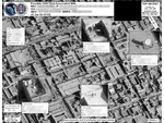
GHOSTHUNTER aerial image (2009) [pdf]
This imagery showcases a real-world application of the GHOSTHUNTER program operated out of Menwith Hill Station in the UK. The document features an aerial satellite photograph used to pinpoint the precise physical location of VSAT (Very Small Aperture Terminal) satellite dishes. By linking a target's digital footprint—specifically their MAC address and IP address—to a specific set of geographic coordinates, the NSA and GCHQ can identify the exact building or compound where a person is using the internet. This capability is a cornerstone of the "find, fix, finish" cycle used to support "covert operations" and targeted killing missions in conflict zones like Yemen, Somalia, and Afghanistan.
Programs: GHOSTHUNTER